During the 2026 breeding season, the Flemish Land Agency (VLM) is combining wet grassland management, experienced field observation and new monitoring technologies across seven FARMBIRD pilot plots. The first field results show how these different elements can help farmers, land managers and conservationists understand what birds need—and act on that knowledge.
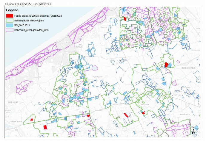
Across the Oudlandpolder in West Flanders, VLM team members Bregt De Smet, Tom Vermeire, Bert Dekock and Frank Stubbe are following the development of seven pilot plots throughout the breeding season. The plots are located within the meadow-bird areas of Klemskerke, Vijfwege and Houtave–Zuienkerke.
The work is part of FARMBIRD, an Interreg North-West Europe project that brings together farmers, land managers, scientists, conservationists and citizens. Across 14 European pilot sites, the partners are testing how improved monitoring can support practical decisions about nests, chicks, adult birds, habitat quality and land management.
Following the birds through the season
Each of the seven Oudlandpolder plots is surveyed several times: at the end of March, around 20 April and again around 20 May. Observers record the birds they see and pay particular attention to behaviour that may indicate breeding, such as displaying, alarm calling or adults occupying suitable nesting habitat.
Most observations are made from the edge of the field. Entering the plots is kept to a minimum to reduce unnecessary disturbance. From mid-April onwards, systematic drone flights have provided an additional view of the plots and helped the team assess the sites in a consistent way.
The monitoring has already recorded characteristic wet-grassland birds, including Northern Lapwings, Black-tailed Godwits, Common Redshanks, Eurasian Oystercatchers and Common Snipes. Other species use the plots to feed, rest or raise their young.
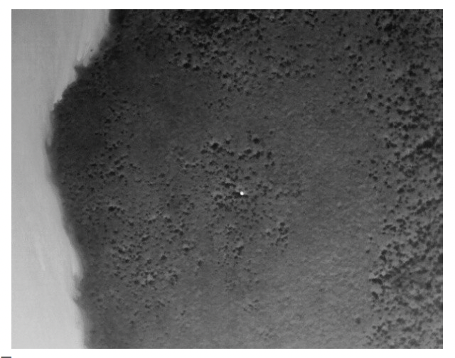
On 20 April, for example, a drone equipped with a thermal camera helped the team locate a Northern Lapwing nest containing four eggs in Zuienkerke. Black-tailed Godwits, Common Redshanks and a pair of Grey Partridges were also recorded in and around the plot that day.
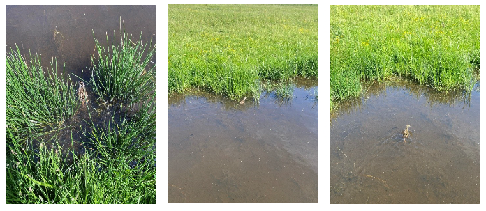
Later in the season, three Common Redshank chicks were seen during a field visit. At another plot, observers found a Common Redshank nest with four eggs, as well as two Eurasian Coot nests.
The plots are also valuable to birds outside the breeding population. At one shallow-flooded site, observers recorded 157 Ruffs on 30 April, together with Wood Sandpipers, Green Sandpipers, Spotted Redshanks and other migratory waders during the spring.
Bringing water back into the landscape
Monitoring is only one part of the work. All seven plots are being rewetted using meadow pumps.
VLM is working with Regional Landscape Houtland & Polders to bring water from local watercourses onto selected parcels. Existing natural drainage lines are maintained, while measures slow the water as it moves through the landscape. Water can then remain in shallow channels and lower-lying depressions instead of immediately draining away.
This creates a more varied wet-grassland landscape. Shallow water and damp soil can provide feeding areas, while differences in vegetation height offer birds a choice of places for nesting, shelter and foraging.
The observations also show why the wider landscape matters. On one plot, several alarm-calling Black-tailed Godwits appeared to have moved with their chicks to neighbouring grassland where the vegetation was shorter and food was easier to reach. Monitoring therefore helps the team look beyond individual nests and understand how birds use a group of connected fields during different stages of the breeding season.
Seeing more while entering fields less
Thermal drone monitoring can reveal warm objects that are difficult to see in normal images, including an incubating bird or a nest hidden in vegetation. During a flight, the pilot follows a planned route while a spotter maintains visual contact with the drone and watches the surrounding airspace. A field observer can then be guided towards a possible nest when verification is necessary.
Tests during April showed that thermal images could identify Northern Lapwing and Black-tailed Godwit nests. Adjusting the thermal camera settings helped nests stand out more clearly against the background. The team also tested predefined waypoint routes and automated software that can conduct a grid flight, identify possible heat sources and store the information for later review.
The first results also show the technology’s limits. Nests are easier to detect than mobile, well-camouflaged chicks. Wind can affect image quality, and birds may sometimes react to the drone. Experienced pilots and field observers therefore remain essential.
The drone is not a replacement for their knowledge. It is an additional tool that can help them search more systematically, record accurate locations and reduce the need to walk through fields. Storing nest coordinates directly from the air may also help limit disturbance and reduce the risk of people accidentally creating tracks that lead predators towards a nest.
Learning what works in practice
The field season is also generating practical lessons about organising drone monitoring. Different plots are subject to different airspace procedures, notification periods and altitude restrictions. Flights must therefore be carefully coordinated with weather forecasts, qualified personnel and the relevant authorities.
These operational lessons are important. A monitoring method is only useful when it is safe, legally compliant, affordable and realistic for the people who need to use it.
VLM brings a strong practical perspective to this work. As the Flemish authority responsible for management agreements and agri-environmental schemes, it works directly with farmers and has expertise in rural development and habitat restoration. Within FARMBIRD, VLM is establishing two Flemish pilots with INBO: one focusing on meadow birds and another on farmland birds. VLM’s agricultural advisers will connect monitoring results with farmers, voluntary management measures and future policy development.
The next steps
Audio recorders and cameras will be introduced at several locations during the next stages of the pilot. Combined with field observations and drone surveys, they will help build a fuller picture of which species are present, where breeding takes place and how birds use the habitat over time.
The findings from the Oudlandpolder will be shared with FARMBIRD partners in Belgium, France, Germany, Ireland and the Netherlands. Together, the partners will assess which combinations of habitat management and monitoring are accurate, practical and useful to farmers, volunteers, conservationists and public authorities.
The first season is already showing the value of combining different kinds of knowledge. Water management creates new opportunities for birds. Local observers understand what is happening in the field. New tools help them see more while disturbing less.
By bringing these strengths together, better observations can lead to better decisions—for the birds and for the people managing their habitats.
We Fly Together.
FARMBIRD is co-funded by the European Union through the Interreg North-West Europe programme.